



Eclipse road closures in Iceland
Every road Vegagerðin is closing, reversing or managing on 12 August 2026 — with the times, the parking, and the rules that get a car towed.
Traffic management starts at 08:00 on Wednesday 12 August 2026 and runs all day. Capital-region streets close 15:00–20:00. 6 roads close outright and 5 become one-way, concentrated where the crowds go: the Seltjarnarnes shoreline, two seafront approaches in west Reykjavík, Álftanes, the whole west run of Snæfellsnes, Klofningsvegur in Dalabyggð, and the single road out to Látrabjarg. Grótta is closed to access for the entire day. The Ring Road is not closed.
Ring Road (R1) slippery in placesHighlands: 56 of 64 monitored roads closed or impassableVegagerðin, updated just now
This is Vegagerðin's published plan, read on 31 July. They are explicit that measures can start earlier than stated and that more can be added, so on the day itself trust the checkpoint in front of you over any page, including this one. The official interactive map of capital-region closures and gathering points is at solmyrkvi2026.is, and the source for everything below is Vegagerðin's eclipse page.
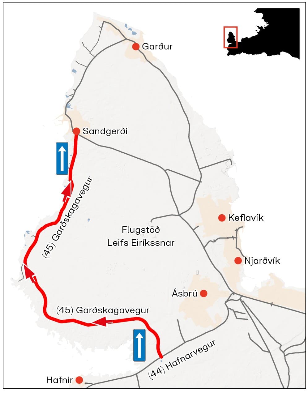
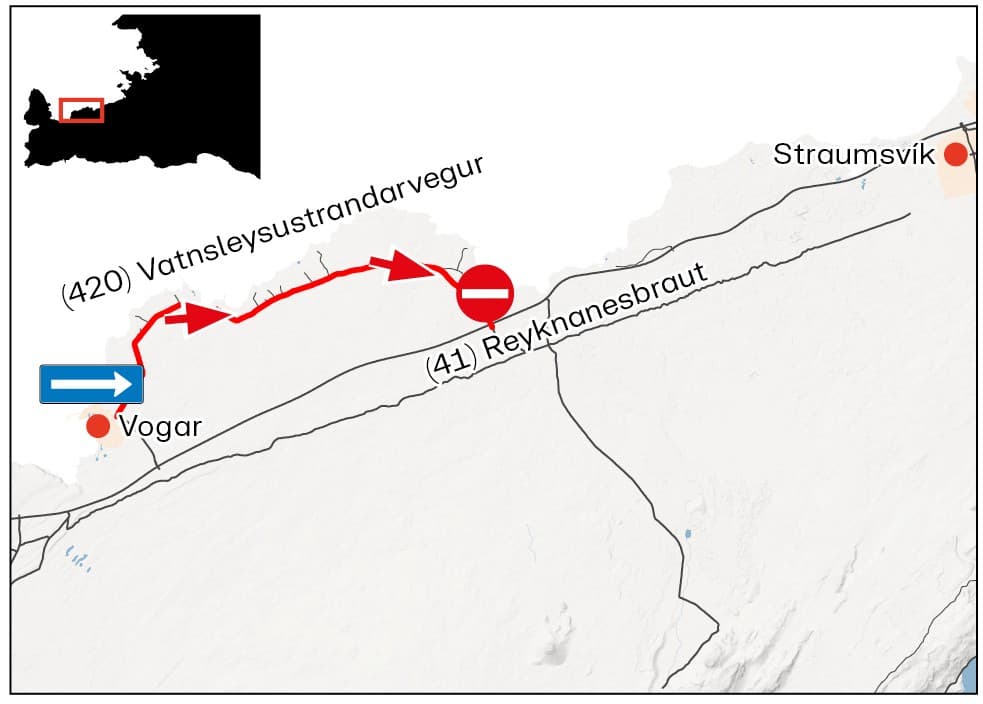
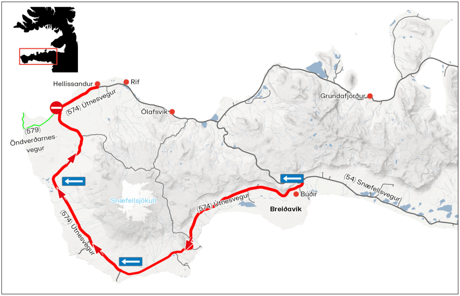
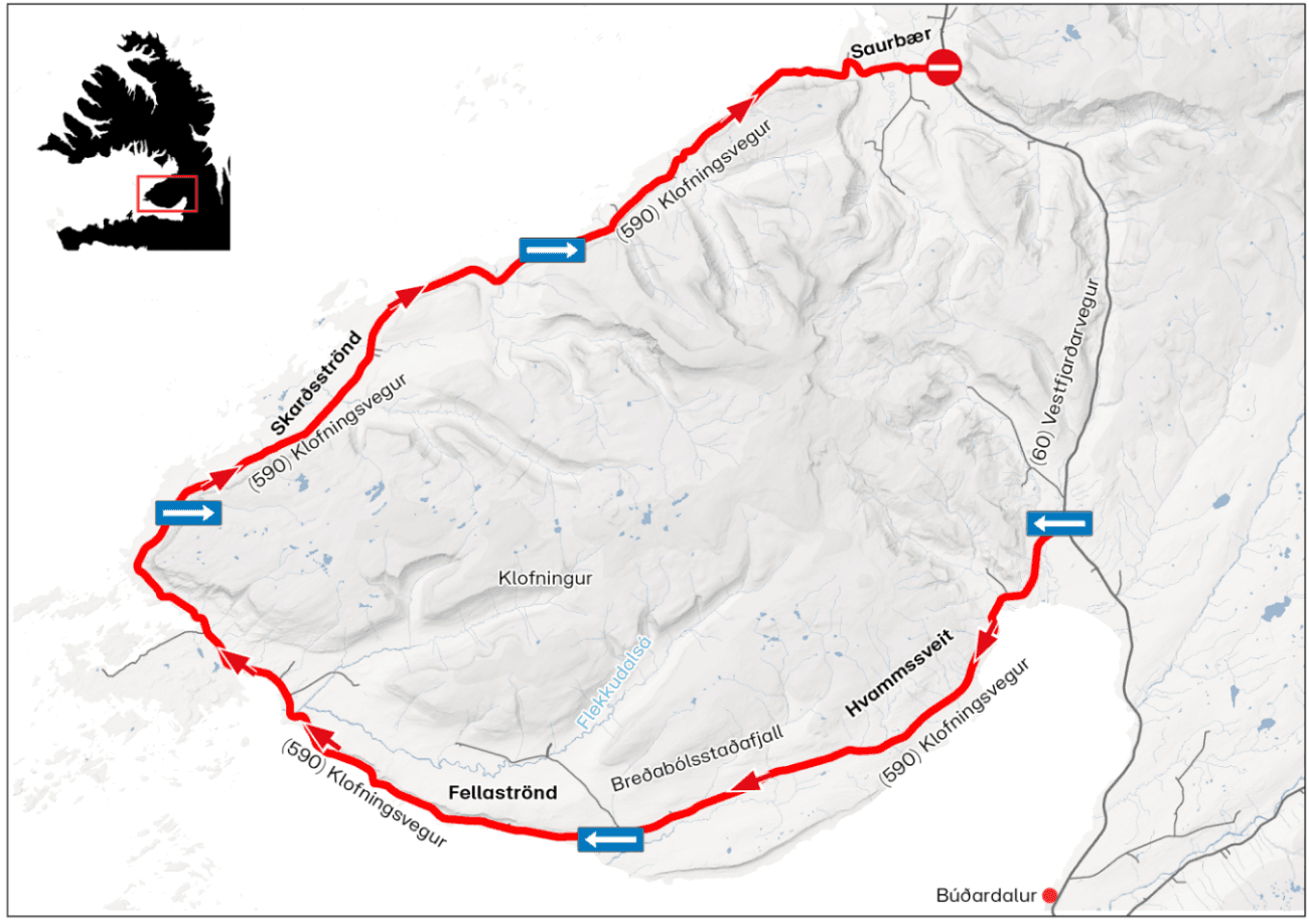
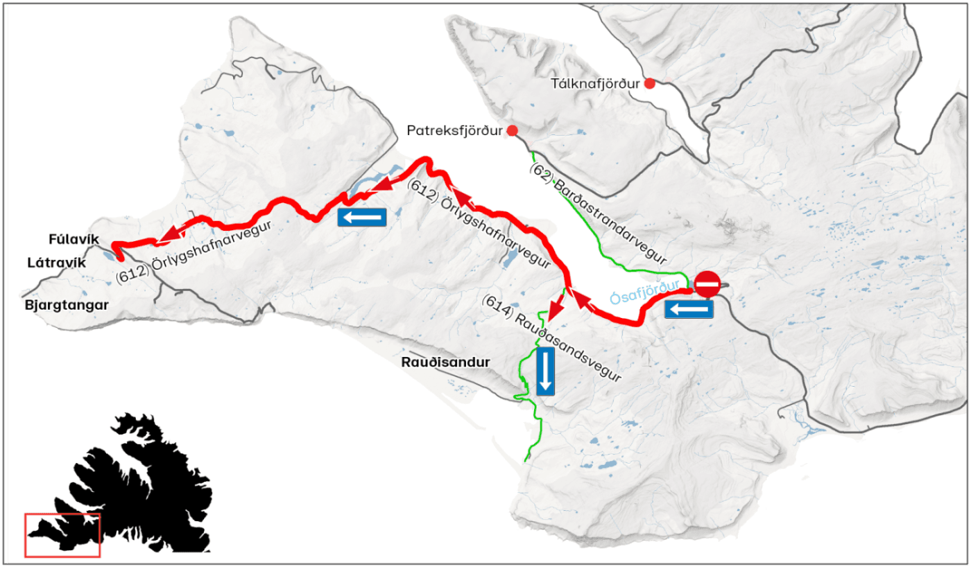
The direction maps below each region are Vegagerðin's own, reproduced with credit and served from their site so you always get their current version. If a map and this page ever disagree, the map wins — it is the authority's.
The four rules that actually bite
Most of this page is timing you can plan around. These four are the ones with a cost attached.
- No parking on the roadway or the shoulders anywhere under traffic management. Vehicles left there are removed at the owner’s expense — Vegagerðin says so in those words, for both Látrabjarg and Útnesvegur on Snæfellsnes.
- Buses over 19 passengers plus driver cannot use the Látrabjarg road on 12 August at all.
- Grótta is closed to access for the whole day, not just during the closure window.
- Speed limits are likely to be reduced more widely on the day. Assume every drive takes longer than the map says.
Road by road
Iceland keeps GMT all year, so every time below is both local time and UTC. Totality crosses the country between 17:43 and 17:50 — the capital-region window brackets it by hours on each side, because the traffic is the problem, not the two minutes of dark.
Seltjarnarnes
The shoreline streets closest to the water shut for five hours, and Grótta — the spot most people picture — is off limits all day.
| Road | Measure | Where | When |
|---|---|---|---|
| Suðurströnd | Closed | from the Vivaldi sports field and swimming pool at the east end to Lindarbraut and Nesbali at the west end | 15:00–20:00 |
| Norðurströnd | Closed | west of Lindarbraut | 15:00–20:00 |
| Road to Grótta | Closed | at Lindarbraut | 15:00–20:00 — and access to Grótta itself is not permitted at any point on the day |
- Suðurströnd: Every side street feeding Suðurströnd closes with it.
- Road to Grótta: High tide falls across the totality window, so the causeway is the wrong place to be regardless of the road.
Where to leave the car: By the swimming pool · Austurströnd · Eiðistorg.

Reykjavík
Two seafront approaches in the west of the city close. The rest of Reykjavík keeps driving — but everyone is heading the same way.
| Road | Measure | Where | When |
|---|---|---|---|
| Suðurgata | Closed | at Hringbraut | 15:00–20:00 |
| Ægisíða | Closed | at Hofsvallagata, Fornhagi and Dunhagi | 15:00–20:00 |
- Suðurgata: All side streets onto Suðurgata close too. Þorragata is the one exception and stays open for traffic into Skerjafjörður.
- Ægisíða: Vehicle access at Lynghagi and Starhagi is closed for the same window.
Garðabær — Álftanes
Álftanes goes one-way. Once you are on the peninsula you leave the way the system sends you, not the way you came.
| Road | Measure | Where | When |
|---|---|---|---|
| Álftanesvegur and Suðurnesvegur | One-way | from the roundabout at the Bessastaðir turn-off | 15:00–20:00 |
Where to leave the car: By the sports centre and swimming pool · The fields west of the sports centre.
Reykjanes
No closures — but two roads are actively managed because the peninsula is where the shadow leaves Iceland, and a lot of people know it.
| Road | Measure | Where | When |
|---|---|---|---|
| Garðskagavegur (Road 45) | Managed | Nesvegur → Sandgerði | from 08:00 |
| Vatnsleysustrandarvegur (Road 420) | Managed | Vogar → Kúagerði | from 08:00 |
Snæfellsnes
The whole south-to-west run of the peninsula becomes one-way, and the road to the tip is closed to private cars.
| Road | Measure | Where | When |
|---|---|---|---|
| Útnesvegur (Road 574) | One-way | Búðir → Hellissandur | from 08:00, when island-wide traffic management begins |
| Öndverðarnesvegur (Road 579) | Closed | — | all day |
- Útnesvegur (Road 574): Police intend to remove illegally parked vehicles here, the same as at Látrabjarg.
- Öndverðarnesvegur (Road 579): Snæfellsjökull National Park runs a shuttle bus for visitors who want to reach the area.

Dalabyggð
The coastal loop north of the peninsula runs one direction only.
| Road | Measure | Where | When |
|---|---|---|---|
| Klofningsvegur (Road 590) | One-way | Hvammsveit → Fellsströnd → Skarðsströnd → Saurbær | from 08:00, when island-wide traffic management begins |
Westfjords — Látrabjarg
The strictest rules in the country, because Látrabjarg gets the longest totality anywhere in Iceland — 2 minutes 13 seconds — down a single road.
| Road | Measure | Where | When |
|---|---|---|---|
| Örlygshafnarvegur (Road 612) | One-way | Barðastrandarvegur → Örlygshöfn | checkpoint in place by 08:00, possibly earlier |
| Rauðasandsvegur (Road 614) | One-way | Barðastrandarvegur → Rauðisandur | from 08:00, when island-wide traffic management begins |
- Örlygshafnarvegur (Road 612): The checkpoint sits at the junction of Barðastrandarvegur (Road 62) and Road 612. Buses are capped at 19 passengers plus driver (19+1) — larger vehicles will not be allowed through. Vegagerðin’s word for parking here is “strictly prohibited”: you arrive, you are counted through, you do not leave a car by the road.

Kópavogur and Hafnarfjörður
No closures planned in either — which does not mean an easy drive.
| Road | Measure | Where | When |
|---|---|---|---|
| All roads | No closure | — | Wednesday 12 August 2026 |
- All roads: Heavy traffic is expected on Reykjanesbraut towards Reykjanesbær, and Björk and Smekkleysa’s Echolalia festival runs at Víðistaðatún in Hafnarfjörður the same day.
Látrabjarg: the longest totality, the tightest road
Látrabjarg gets about 2 minutes 13 seconds of totality — the longest anywhere in Iceland — reached by one road with a checkpoint on it. Vegagerðin has set speed limits for the run, the second one specifically because of how many people will be walking on the road.
The end of Road 612
Látrabjarg sits at the far west end of Örlygshafnarvegur (612). The checkpoint goes in at the junction with Barðastrandarvegur (62), off the right of this view — everything between there and this pin is one-way on 12 August.
| Section | Limit |
|---|---|
| The road generally | 60 km/h |
| Breiðavík → Látrabjarg | 50 km/h, for the number of people on foot |
If your vehicle carries more than 19 passengers plus a driver, it will not be let through on the day. If you leave a car on the road or the shoulder, it gets removed and you pay for that. Both of those are Vegagerðin's words, not a cautious reading of them.


If you move freight
Vegagerðin has asked freight, cargo, fish and fuel transport operators to keep off the western half of the country on 12 August as far as they can.
- Postpone transport where the schedule allows it
- Travel outside the peak hours around the eclipse
- Avoid the most affected areas entirely on the day
The point is not tidiness. Heavy traffic on single-lane roads is what stops an ambulance getting through, and these measures exist mainly to keep emergency access open.
Cars & campers
 KEF airport pickup 24/74.8
 Transmission
 Fuel
Fuel Seats
Seats Drive
Drive

 Sleeps
Eclipse driving questions
What time do the eclipse road closures start in Iceland?
Can I drive to Grótta for the eclipse?
Can I drive to Látrabjarg to see the longest totality?
Which roads become one-way for the eclipse?
Is the Ring Road closed for the eclipse?
Where can I park near the closed streets in Reykjavík and Seltjarnarnes?
Tours near the eclipse path
 Small groups
 Duration
 Highlights
 Type
Type
