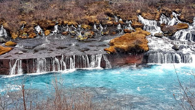
Hornstrandir1 · Wikimedia Commons · CC BY-SA 4.0
 Berserkur · Wikimedia Commons · CC BY-SA 4.0
 Michal Klajban · Wikimedia Commons · CC BY-SA 4.0
Reykjavík Area Lakes

14 lakes in Reykjavík Area — mapped with live road conditions, drive times, and directions.
14 lakes in Reykjavík Area, led by Úlfljótsvatn and Þingvallavatn. All mapped with drive times, directions, and live road conditions.
Top lakes in Reykjavík Area
The region's stand-outs — each with photos, facts, and its own page. Distances on the cards are straight-line from Reykjavík.
 2.45 km² surface
Úlfljótsvatn
Úlfljótsvatn is a lake in southern Iceland, to the south of lake Þingvallavatn, 74km east of Reykjavík. Úlfljótsvatn is named after Úlfljótr, an important man who was involved in the Alþingi in 930. Icelandic lake, part of the island's diverse landscape of water and fire. Check if swimming is permitted - some lakes are protected or dangerous.
 83 km² surface
Þingvallavatn
Iceland's largest natural lake, right in Þingvellir National Park where the tectonic plates meet. The water clarity is exceptional - visibility can exceed 100 meters. Silfra fissure, where you can snorkel between continents, drains from this lake. The Viking parliament (Alþingi) met on these shores for centuries. History and geology combine in one UNESCO World Heritage Site. Golden Circle essential. Easy day trip from Reykjavík but worth spending more time. Diving and snorkeling operators run trips year-round.
 9 km² surface
Kleifarvatn
Large lake on the Reykjanes peninsula, close to Reykjavík. Geothermal vents bubble at the lake's edge. The drive around the lake passes volcanic landscapes and hot spring areas. Good for a half-day trip from the capital. During droughts, the lake level drops dramatically - underground fissures drain the water. Overlooked in favor of the Golden Circle. Worth the detour.

Tjörnin
Tjörnin is a small, prominent lake in central Reykjavík, the capital of Iceland. Most visitors to the city pass along its shore, as it is situated in the city centre next to the Reykjavik City Hall and several museums. Tjörnin means "the pond". Icelandic lake, part of the island's diverse landscape of water and fire. Many lakes are inaccessible in winter - plan seasonal visits accordingly.

Leirvogsvatn
Leirvogsvatn is a small lake, located about 23 kilometres (14 mi) northeast of Reykjavík, Iceland. It lies along Route 36. Located at 211 metres (692 ft) above sea level, it has an area of 1.2 square kilometres (0.46 sq mi) with a maximum depth of 16 metres (52 ft). Fed by the Leirvogsvatn River, the lake is the subject of a legend in the form of a horse-shaped monster. The lake is known to contain populations of Gasterosteus islandicus. Icelandic lake, part of the island's diverse landscape of water and fire. Check if swimming is permitted - some lakes are protected or dangerous.

Rauðavatn
Lake Rauðavatn is a lake on the eastern side of Reykjavík, north of Elliðavatn. The Route 1 ring road passes the lake to the west, separating it from the suburb of Árbær. Icelandic lake, part of the island's diverse landscape of water and fire. Fishing requires permits in Iceland - check regulations before casting.
14 lakes in Reykjavík Area
 0.3 km² surface
Vífilsstaðavatn
Icelandic lake, part of the island's diverse landscape of water and fire. Many lakes are inaccessible in winter - plan seasonal visits accordingly.

Langavatn
Icelandic lake, part of the island's diverse landscape of water and fire. Fishing requires permits in Iceland - check regulations before casting.

Djúpavatn
Icelandic lake, part of the island's diverse landscape of water and fire. Fishing requires permits in Iceland - check regulations before casting.

Kaldá
Icelandic lake, part of the island's diverse landscape of water and fire. Fishing requires permits in Iceland - check regulations before casting.
2.45 km² surfaceÚlfljótsvatn
Úlfljótsvatn is a lake in southern Iceland, to the south of lake Þingvallavatn, 74km east of Reykjavík. Úlfljótsvatn is named after Úlfljótr, an important man who was involved in the Alþingi in 930. Icelandic lake, part of the island's diverse landscape of water and fire. Check if swimming is permitted - some lakes are protected or dangerous.
83 km² surfaceÞingvallavatn
Iceland's largest natural lake, right in Þingvellir National Park where the tectonic plates meet. The water clarity is exceptional - visibility can exceed 100 meters. Silfra fissure, where you can snorkel between continents, drains from this lake. The Viking parliament (Alþingi) met on these shores for centuries. History and geology combine in one UNESCO World Heritage Site. Golden Circle essential. Easy day trip from Reykjavík but worth spending more time. Diving and snorkeling operators run trips year-round.
9 km² surfaceKleifarvatn
Large lake on the Reykjanes peninsula, close to Reykjavík. Geothermal vents bubble at the lake's edge. The drive around the lake passes volcanic landscapes and hot spring areas. Good for a half-day trip from the capital. During droughts, the lake level drops dramatically - underground fissures drain the water. Overlooked in favor of the Golden Circle. Worth the detour.
Tjörnin
Tjörnin is a small, prominent lake in central Reykjavík, the capital of Iceland. Most visitors to the city pass along its shore, as it is situated in the city centre next to the Reykjavik City Hall and several museums. Tjörnin means "the pond". Icelandic lake, part of the island's diverse landscape of water and fire. Many lakes are inaccessible in winter - plan seasonal visits accordingly.
Leirvogsvatn
Leirvogsvatn is a small lake, located about 23 kilometres (14 mi) northeast of Reykjavík, Iceland. It lies along Route 36. Located at 211 metres (692 ft) above sea level, it has an area of 1.2 square kilometres (0.46 sq mi) with a maximum depth of 16 metres (52 ft). Fed by the Leirvogsvatn River, the lake is the subject of a legend in the form of a horse-shaped monster. The lake is known to contain populations of Gasterosteus islandicus. Icelandic lake, part of the island's diverse landscape of water and fire. Check if swimming is permitted - some lakes are protected or dangerous.
Rauðavatn
Lake Rauðavatn is a lake on the eastern side of Reykjavík, north of Elliðavatn. The Route 1 ring road passes the lake to the west, separating it from the suburb of Árbær. Icelandic lake, part of the island's diverse landscape of water and fire. Fishing requires permits in Iceland - check regulations before casting.
 1.8 km² surface
Elliðavatn
Elliðavatn is a lake in Iceland. It is situated in the area of Reykjavík. Icelandic lake, part of the island's diverse landscape of water and fire. Weather can change rapidly around highland lakes - be prepared.
 1.02 km² surface
Hafravatn
Hafravatn is a small lake on the eastern outskirts of Reykjavík, Iceland. Located at 76 m above sea level, it has an area of 1.08 km2 (0.42 sq mi) with a greatest depth of 28 m (92 ft). The Seljadalsá River flows into it from the east and its discharge is Úlfarsá. A small village lies on the northern bank of the lake and a paragliding take-off point on its eastern side. The smaller lake of Langavatn lies to its southwest. Icelandic lake, part of the island's diverse landscape of water and fire. Fishing requires permits in Iceland - check regulations before casting.

Reynisvatn
Reynisvatn is a lake on the eastern side of Reykjavík, east of Grafarholt og Úlfarsárdalur. The lake is a popular fishing spot, with rainbow trout being released. Icelandic lake, part of the island's diverse landscape of water and fire. Weather can change rapidly around highland lakes - be prepared.
Cars & campers
 KEF airport pickup 24/74.8
 Transmission
 Fuel
Fuel Seats
Seats Drive
Drive

 Sleeps
Tours near Reykjavík Area
 Small groups
 Duration
 Highlights
 Type
Type